Angie Vasquez

Sunday, February 26, 2006

Punta Arenas, Rio Gallegos, and Puerto Madryn


We met up with Andreas - a guy from Germany that we had met on the Ruta 40 trip - in Punta Arenas. There isn't anything all that spectacular about this city aside from the fact that it sits on the Straits of Magellan. We stayed here for a couple of days while waiting for a bus up to Rio Gallegos and then on to Puerto Madryn. The hostel we stayed in, while not exactly nice, included a great breakfast and a very friendy owner who was nice enough to wash our shoes and jackets for us by hand. Puerto Madryn sits on the Eastern Coast of Argentina about 1/2 way up the country and is famous for it's sea lions, sea elephants, penguins and whales on the Valdez Peninsula. The four of us rented a car for the day and spent the day driving on the Peninsula. It was more driving than we expected to get to the various points for viewing the penguins etc. but worth the trip and a nice way to break up the trip to Buenos Aires. It was also a nice, relaxing town and I stayed here for 3 days before the 20 hour bus ride to Buenos Aires. The bus ride proved to be one of the more uncomfortable long trips I had, with rock hard seats and the good fortune of being seated next to a family with six kids and a guy that insisted on using my shoulder as his elbow rest. But I was happy that they weren't throwing-up like the kids next to me on the bus in Peru.

Puerto Natales and Torres Del Paine


From El Calafate, I headed to Puerto Natales, Chile with an Australian couple that I had met on the Ruta 40 trip. Puerto Natales is one of the two staging cities for hiking Torres Del Paine. Here we rented camping gear and then headed out to do the famous "W" trek. Fortunately the weather was more cooperative than it was in El Chalten. The first day we hiked next to numerous floating icebergs in Lago Gray and experienced the craziest wind I've ever been in - I'm guessing consistent winds of at least 45-55 mph in some of the exposed areas. We had to stop and take the waterproof covers of our packs for fear that the wind would rip them off. After about 6 hours, we set up camp next to Gray's Glacier. The views were spectacular, and this ended up being one of my favorite parts of the trek. We spent a total of 5 days and 4 nights trekking. The scenery varied each day, from the glacier on the first day, to hiking along snow-capped mountains watching numerous avalanche's, to rushing waterfalls, and more tropical forested areas. The final day we got up early to bolder up the Rio Ascensio for a view of famous towers. The weather was perfect and as the sun rose, it lit up the towers with a warm, golden hue. The emerald-green lakes were so pristine that we could drink from them without filtering the water, and despite their popularity, the trails were kept litter-free. After 5 days we took a shuttle back for a much needed shower in Puerto Natales before heading to Punta Arenas.

Tuesday, February 21, 2006

El Calafate - Perito Moreno Glacier


El Calafate is significantly more developed and touristy than El Chalten, and it's the closest city to Los Glaciares National Park. The park has 2,600 square kilometers of ice fields from which 47 major glaciers descend. The absolute "star" of the glaciers is Perito Moreno Glacier, which is 5km wide, 60m above the surface of the water, and has a total ice depth of around 170m. A series of stairs, walkways, and observation decks were constructed in 1988. Tourists had previously been permitted to descend to the shores of the lake, but after 32 people were killed over a twenty year period by flying chunks of ice created by the calving, observation was restricted to the designated vantage points. The constant movement and pressure of the ice causes stunning peaks and crevasses that take on a variety of incredible blue hues according to the density of the ice. The show was never ending as ice chunks “calved” into the lake below with resounding crashes similar to that of thunder. We also took a boat trip to get a different perspective of the enormousness of the glacier.

Monday, February 20, 2006

Overland Patagonia on Ruta 40 - indubitably a road less traveled.


I left Bariloche and headed for El Chalten on the famous Ruta 40, which is the main road on the Argentine side of Patagonia. The only way to take this route is with a small group, and it consists of driving for about 15 hours each day for two days, with a stop one night at a hostel in the middle of nowhere. We also stopped at the Cueva de las Manos (Cave of the Hands) on the second day to break things up a bit. This route gives a great feel for the magnitude and desolation of Patagonia....miles and miles of dusty, windy, lonely nothingness. We saw road runners (called Ñandu) and guanacos along the way. Much of it consisted of flat plains but as we got closer to El Chalten there were more mountains, lakes, and rivers. The long trip provided a lot of opportunity for conversation with the other travelers, and the bumpy, gravel roads insured that little sleep was to be had. I met some great people, a few of which I ended up traveling with for a while.

The Cave of Hands is prehistoric rock art from 13,000 to 9,500 years ago and consists of outlines of human hands and pictures of animals. It was interesting enough, but I think all of us enjoyed the walking more than anything else after so many hours of driving. And we were all trying to figure out how what seemed to be a thin layer of color could withstand thousands of years of erosion. I'm sure that there is a logical explanation, but the information was in Spanish, and none of us could understand enough of it to figure it out. So, we concluded that some entrepreneurial Argentine must have decided to paint some pictures on rocks and convince naive tourists to pay him $5 to visit them.

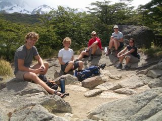
We arrived in El Chalten after two days of driving. El Chalten is a village in National Park Los Glaciares and sits at the foot of Mts. Fitz Roy and Cerro Torre -famous for it's mountaineering and trekking - and on the shores of Lake Viedma. It is the transition area between the Patagonian steppe and the Subantartic forest. El Chalten is very small and appears to exist solely to support climbers and trekkers. There was basically one main gravel road and a few side roads with hostels, restaurants and stores for camping gear. Internet was expensive and SLOW, which is part of the reason for my delinquency in updating my blog. Our hostel had a great atmosphere and was hopping with backpackers doing day-hikes, or preparing for longer excursions. One of the guys I met on the Ruta 40 tour is a big climber and while a group of us were eating pizza, pointed out that two world-famous climbers were sitting behind us. Apparently they were attempting a climb that hadn't been done before, and it's supposedly one of the most difficult climbs in the world - not for it's height but for it's degree of technicality.

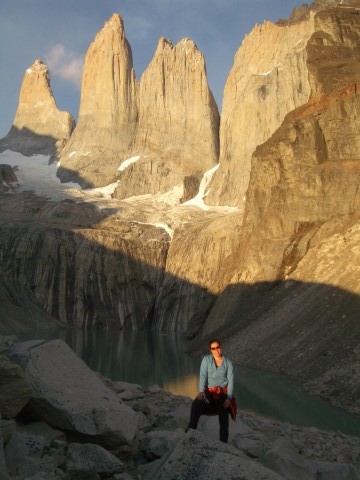
The views in El Chalten were spectacular. I am beginning to feel like I sound like a broken record with how many times I have repeated that statement, but the beauty of this continent continues to shock me. Each new place is awe-inspiring in a different way than the last, so there's little risk for becoming blasé. The name of the town "El Chalten" means mountain that sends out smoke, and it was named that because it was initially believed it to be a volcano because the mountain's summit was always covered with a layer of clouds. The first day a group of us went of a easy hike for a couple of hours after checking out the town and buying supplies for a longer overnight trip that we had planned to start the following day. We came across another of people camping and trying to stay somewhat sheltered from the relentless winds. The atmosphere was almost bewitching in some areas with all the dead, hollowed out trees. We stopped for a snack by a crystal clear, turquoise lake and enjoyed the views of the vertical cliffs and glaciers in the distance.

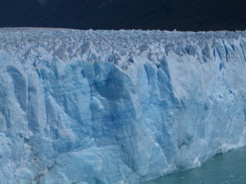
We had planned on starting out early the next morning for a 3-4 day trek, but the unpredictable, Patagonian weather reared it's ugly head in the middle of the night. The winds were so strong that it was basically pouring side-ways. The rain let up a little by morning, but the cold, strong winds put a halt on our trekking excursion. The one benefit of the crazy winds is that the weather moves through relatively quickly, and as a result, it improved enough in the afternoon to venture out for another day hike. It was overcast and still very windy, but we could still see the mountains percolating through the clouds. Most of the group turned back after an hour or two, but a girl from Germany and I decided to go farther. We were able to get pretty close to the incredible blue-tinted glaciers of the ice field layered on top of the mountains. Earlier in the day I had decided not to stay in El Chalten and risk that we would again have bad weather the following day, and I was glad that I at least got some good day hikes in. But having a taste of the incredible scenery made it difficult to leave. Most of us left that night on a bus to El Calafate to visit the famous Perito Moreno Glacier.

Wednesday, February 15, 2006

Bariloche - the Lakes District of Patagonia


I had heard great things from other travelers about Bariloche, and given how difficult it was to get there, I figured it must be good. It is situated on the foothills of the Andes and sits on Lake Nahuel Huapi. It is also famous for it's chocolate, and that fact alone was enough to convince me that it was a city worth visiting. Not that I needed any chocolate after over-indulging on ice cream in Mendoza - I don't think I have ever seen so many heladerias.

Bariloche is definitely a beautiful city with an alpine village feel, but I was a little disappointed by how touristy it was. And the fact that it's also a hot spot for Argentine high school graduates on summer vacation. Despite all the tourists, the areas surrounding the city are stupendous and there is loads of hiking, biking, kayaking, and rafting. I went kayaking one of the days, and the lake was one of the cleanest I've ever seen. Unlike the part of the Amazon River that I visited, Patagonia seems to be much more environmentally protected. And there were fewer tourists outside of the city. I stayed a few days in Bariloche and then took the "Ruta 40" trip down to Southern Patagonia.

Tuesday, February 14, 2006

Mendoza, Spanish lessons, musical hostels and serious siestas

I had initially planned on just spending a couple of days in Mendoza, but my plans were thwarted again by vacationing Argentines. The first available bus to my next destination, Bariloche, was a week-and-a-half later. Fortunately Mendoza proved to be a enjoyable city, and the extra time enabled me to take some Spanish lessons. And lessons were much needed as Spanish in Argentina hardly seemed recognizable. I had been getting by in Peru in Bolivia, but Argentines speak much faster and use slightly different rules. I took just over a week of classes, and my instructors were very helpful, and quite entertaining. Apparently I entertained them as well when trying to describe a man working on his computer in Spanish. I still have much to learn because rather than saying he was working on his computer, I said that he was pissing on his computer. The school made sure that we got a taste of the nightlife as well. I've always considered myself a bit of a night owl, but in Mendoza, I think even the senior citizens and toddlers outlasted me. Apparently 2:30 a.m. is early, which explains why they take their siestas so seriously. Just about everything shuts down from 1:00 to 6:00 in most Argentine cities. Banks and government offices are generally only open from 9am to 1pm. Rough life! Apparently there is some fantastic hiking around Mendoza as well, but my Spanish lessons made it difficult to make it out of the city. I did manage to make it on one wine tour though. AndI checked out a good number of the hostels in Mendoza as musical hostels was necessary due to the busy travel season. I think I changed hostels around 5 times in the week-and-a half that I was there.